Featured Projects
Engineering-grade digital solutions that help our clients design, build, and operate with confidence
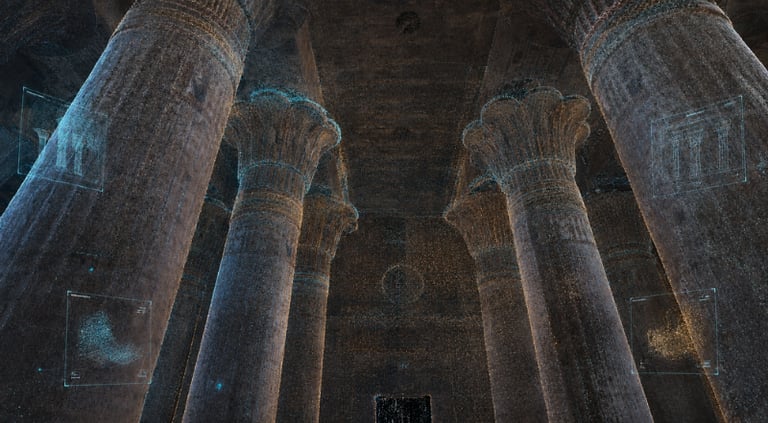
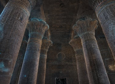
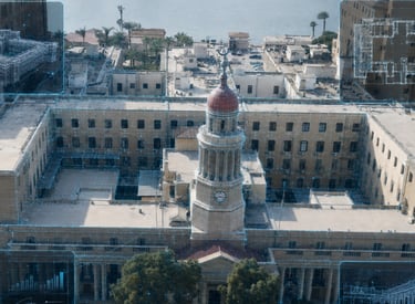
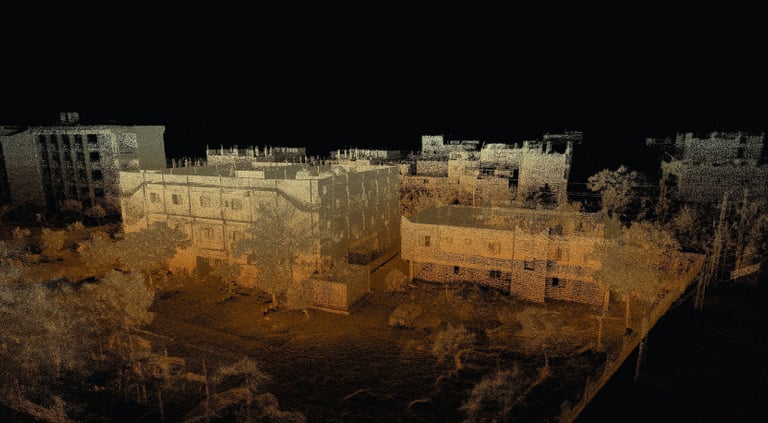
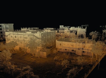
Historic Buildings in Esna
➤ Esna, Egypt 𝄜 2023
To create accurate digital documentation of selected historic buildings, streets, and landmarks in Esna before development and conservation works.
Workflow
Reality Capture
Heritage Documentation
Georeferenced Survey Workflow
High-Detail 2D Documentation
3D Modeling
Digital Deliverables
Registered Point Cloud
Georeferenced Spatial Data
Detailed AutoCAD Drawings
High-Fidelity Scaled Models
Heritage Imagery
Esna is an important touristic city in Egypt with valuable architectural and cultural landmarks. The project was performed in collaboration with an engineering company involved in integrated community development. The wider development work later received the Aga Khan Award for Architecture, reflecting the cultural and urban significance of the project.
Project Purpose
Project Context
Why It Mattered
The project created a reliable digital record of Esna’s heritage environment before development works, supporting conservation, architectural understanding, and long-term documentation of culturally significant urban assets.
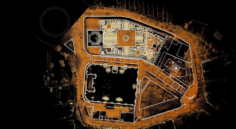
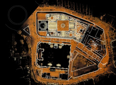
Sultan Hassan & Refai Mosques
➤ Cairo, Egypt 𝄜 2022
To document two major Islamic heritage landmarks and produce accurate plans, elevations, and surrounding layouts before maintenance and restoration activities.
Workflow
Reality Capture
Heritage Documentation
As-Built Documentation
Architectural Survey
Spatial Layout Documentation
Digital Deliverables
Registered Point Cloud
Site Layout Drawings
Elevation Drawings
Plan Drawings
Spatial Documentation Records
Sultan Hassan and Al-Refai Mosques are among Cairo’s most important Islamic architectural landmarks, known for their historical value, monumental scale, and rich architectural detail. The project required accurate spatial documentation of the mosques and their surrounding area to serve as a technical reference before maintenance works. The work involved sensitive heritage environments, difficult lighting conditions, and abandoned internal spaces that had not been used for many years. Some areas contained living bats, adding access and fieldwork challenges for the scanning team.
Project Purpose
Project Context
Why It Mattered
The documentation provided a measurable reference for maintenance planning, architectural review, and future conservation decisions for two highly significant Islamic heritage assets.
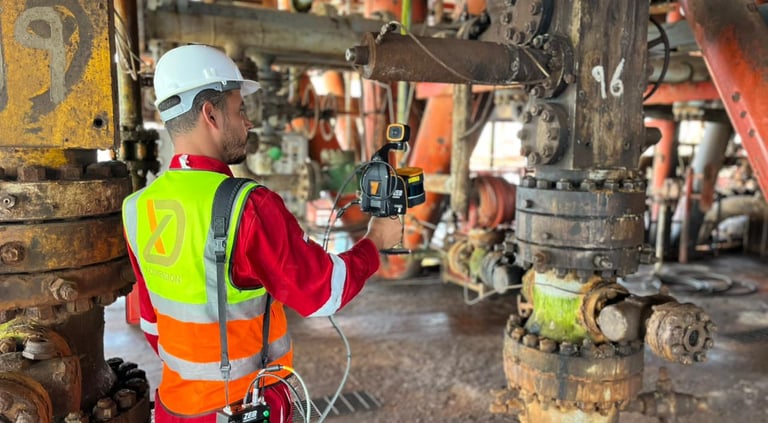
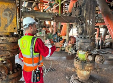
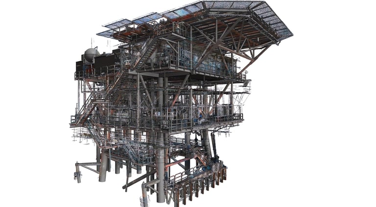
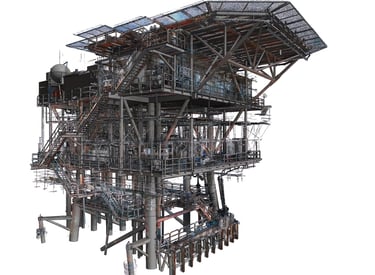
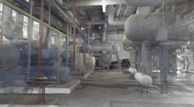
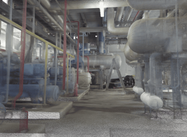
Morgan 1 - Red Sea
➤ Red Sea, Egypt 𝄜 2026
To create an accurate as-built digital representation of an operating oil and gas platform, including geometry, asset information, intelligent modeling, and engineering drawings.
Workflow
Reality Capture
SLAM-Based Mobile Scanning
Oil & Gas As-Built Documentation
Intelligent 3D Modeling
P&ID-Based Model Development
Digital Deliverables
Registered Point Cloud
Intelligent Plant 3D Model
General Arrangement Drawings
Isometric Drawings
Engineering Documentation
Morgan 1 is an active offshore oil and gas platform in the Red Sea. The project required rapid documentation of the existing operational condition and the development of an intelligent model suitable for engineering and operational reference. The timeline was highly compressed, with site capture completed in approximately two to three days. To meet project requirements, X-Dimension combined SLAM-based mobile scanning with available project information and updated P&IDs to produce an intelligent Plant 3D model and related engineering outputs.
Project Purpose
Project Context
Why It Mattered
The project provided a reliable digital foundation for understanding the platform’s actual operating condition, supporting engineering coordination, asset documentation, and future modification or maintenance workflows within a tight delivery window.
SP1 - Red Sea
➤ Red Sea, Egypt 𝄜 2024
To document the as-built condition of a non-operating offshore oil and gas platform and provide digital references for review, planning, and future decision-making.
Workflow
Reality Capture
SLAM-Based Mobile Scanning
As-Built Documentation
Industrial Asset Documentation
Cloud-Based Review
Digital Deliverables
Registered Point Cloud
3D Model
Online Viewer
Spatial Documentation Records
SP1 is an offshore oil and gas platform in the Red Sea that had been out of operation for years. Parts of the platform had deteriorated and were not safe for operational use, making fast and controlled site documentation essential. The project timeline was extremely tight, with scanning completed in one day. X-Dimension used advanced SLAM-based mobile scanning to capture the platform efficiently while maintaining the accepted project tolerance. Online viewers were also used to allow client personnel to navigate the platform remotely at any time.
Project Purpose
Project Context
Why It Mattered
The project enabled remote understanding of a deteriorated offshore platform, reducing the need for repeated physical access and supporting safer planning, technical review, and asset evaluation.
National Bank of Kuwait (NBK) - Administrative Capital
➤ Cairo, Egypt 𝄜 2025
To verify the construction status and as-built condition of a new bank branch against design and shop drawings during execution.
Workflow
Construction Verification
Reality Capture
As-Built Site Documentation
MEP Documentation
BIM-Based Review Support
Digital Deliverables
Registered Point Cloud
Construction Verification Reference
MEP Spatial Documentation
BIM Comparison Support
The National Bank of Kuwait branch in Egypt’s New Administrative Capital was under construction when accurate as-built verification became necessary. The client needed to confirm that the actual site conditions matched the design and shop drawings and to identify any major deviations before later construction stages. The documentation also needed to capture MEP elements and combine them into a spatial reference that could be reviewed against the 3D Revit design model.
Project Purpose
Project Context
Why It Mattered
The project helped the client verify executed works against the design model, reduce construction uncertainty, and support coordination before proceeding with later project stages.
Rashid & Latifa Schools
➤ Nad Al Sheba, UAE 𝄜 2025
To support construction progress monitoring and create accurate MEP as-built records before ceiling closure in a fast-track educational project.
Workflow
Construction Progress Monitoring
Reality Capture
MEP As-Built Documentation
Time-Based Site Capture
BIM Coordination Support
Digital Deliverables
Registered Point Clouds
Online Viewers for Multiple Timeframes
Lightweight Objects Integrated into Revit
MEP As-Built Records
Progress Verification References
Rashid & Latifa Schools is an elite school development in the UAE. X-Dimension’s scope combined periodic construction progress monitoring with detailed MEP documentation before gypsum board ceiling closure. The project was highly challenging due to the fast-track construction schedule, continuous site changes, limited ability to evacuate areas before scanning, difficult georeferencing conditions, and high-temperature weather affecting both equipment and field teams. Despite these constraints, the captured data supported both technical verification and client presentations.
Project Purpose
Project Context
Why It Mattered
The project provided measurable progress visibility and reliable MEP records before concealment, helping the client compare actual works against models, support reporting, and manage coordination in a rapidly changing construction environment.
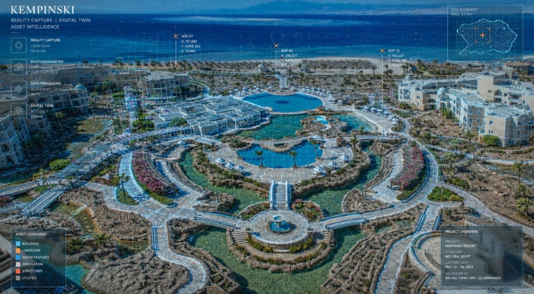
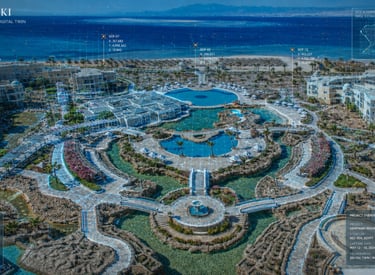
Kempinski - Soma Bay
➤ Hurghada, Egypt 𝄜 2026
To create complete as-built documentation of an operating resort, including rooms, layouts, administrative buildings, internal areas, and external spaces.
Workflow
Reality Capture
Hospitality As-Built Documentation
Interior and Exterior Documentation
Operational Site Coordination
2D Drawing Production
Digital Deliverables
Registered Point Cloud
Elevation Drawings
2D Plans
Resort Spatial Documentation
Kempinski Soma Bay is one of Egypt’s well-known resort destinations. The consultant and owner required accurate documentation of the existing resort environment to support future planning, facility understanding, and operational reference. The main challenge was that the resort was fully operational, with occupied guest rooms and active hospitality functions. X-Dimension coordinated closely with the resort team to access and document rooms with guest permission while minimizing disruption to the guest experience.
Project Purpose
Project Context
Why It Mattered
The project created an accurate digital reference of a live hospitality asset, supporting future renovation, operational planning, and facility management while maintaining sensitivity to guest experience and resort operations.
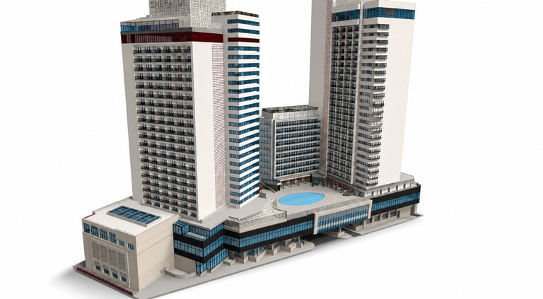
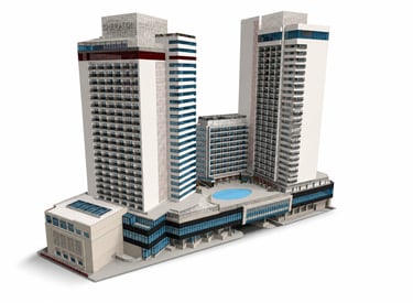
Sheraton Cairo Hotel
➤Cairo, Egypt 𝄜 2022
To document the as-built condition of a landmark hotel tower during rehabilitation and produce accurate facade, interior, and 3D references for renovation works.
Workflow
Reality Capture
Hotel Rehabilitation Documentation
Facade Documentation
As-Built Modeling
Interior Spatial Documentation
Digital Deliverables
Registered Point Cloud
3D Model
2D Drawings
Elevation Documentation
Interior As-Built Records
Sheraton Cairo is one of Cairo’s landmark hotels. One of its towers was undergoing rehabilitation after the removal of old interior finishes, creating a need for accurate as-built documentation before redesign and renewal works. The project also required facade capture to support elevation renewal, as traditional measurement methods were not sufficient to capture the level of detail required. Some occupied rooms were needed to complete the documentation, requiring coordination with the owner’s team.
Project Purpose
Project Context
Why It Mattered
The project provided reliable digital documentation for rehabilitation design, facade renewal, and renovation coordination, reducing dependency on incomplete traditional measurements.
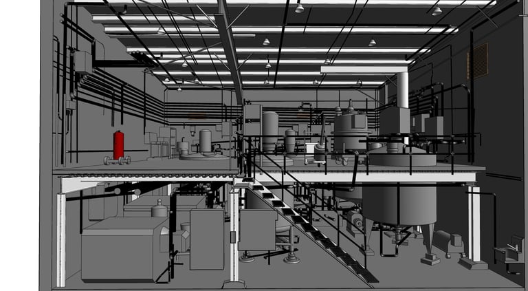
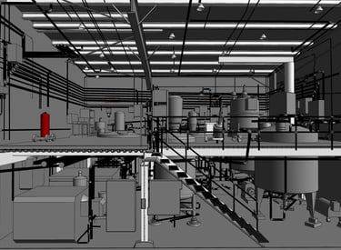
MaxBB1 - Coca-Cola
➤ Cairo, Egypt 𝄜 2025
To create an accurate as-built 3D documentation model for an industrial facility before maintenance and upgrade works.
Workflow
Reality Capture
Industrial As-Built Documentation
3D Facility Modeling
Structural, Architectural, and MEP Documentation
Cloud-Based Review
Digital Deliverables
Registered Point Cloud
3D Model
2D Drawings
Online Viewer
The facility required a complete digital representation of its actual condition, covering structural, architectural, and MEP elements. The model needed to support future maintenance activities, upgrade planning, and technical discussions between stakeholders. X-Dimension documented the facility and produced structured digital references that could be reviewed by project teams through both model outputs and online viewing environments.
Project Purpose
Project Context
Why It Mattered
The project created a reliable digital reference for maintenance and upgrade planning, helping stakeholders review the facility condition, coordinate decisions, and access spatial information during technical discussions.
Orion Foods
➤ Cairo, Egypt 𝄜 2025
To document an industrial facility in 3D and support planning for the installation and movement of new equipment inside the existing operational environment.
Workflow
Reality Capture
Industrial Facility Documentation
3D Modeling
Equipment Placement Planning
Interactive Digital Environment
Digital Deliverables
Registered Point Cloud
Measurable 3D Model
Equipment Maneuvering Support
Online Interactive Environment
The client needed to add new equipment to the facility but was uncertain whether the equipment would fit and how it could be moved through the facility to reach its final position. This required a measurable 3D representation of the existing environment, including clear spatial constraints and handling paths. X-Dimension captured the facility, created a detailed 3D model, and helped visualize the placement and maneuvering process of the new equipment. An online interactive environment was provided to support stakeholder review and planning discussions.
Project Purpose
Project Context
Why It Mattered
The project helped the client evaluate equipment fit, plan the handling route, and reduce installation uncertainty before physical movement, improving coordination and reducing operational risk.

Al-Qasr Al-Ainy Hospitals
➤ Cairo, Egypt 𝄜 2022
To create engineering documentation for 22 hospital buildings during operation to support future renovation and facility planning.
Workflow
Reality Capture
Hospital As-Built Documentation
Operational Facility Documentation
Multi-Building Survey
Facility Information Extraction
Digital Deliverables
Registered Point Cloud
2D Plans
Elevation Drawings
Site Layout
Facility Information References
Al-Qasr Al-Ainy is one of the oldest, largest, and most prestigious educational and research hospitals in the Middle East and Africa. The project required documenting a large and complex healthcare environment while the hospital remained operational. The work involved careful scheduling, coordination with many departments and managers, and controlled access to sensitive areas. Beyond geometric documentation, the digital representation also helped the client extract important facility information such as bed counts, equipment-related data, and other operational references.
Project Purpose
Project Context
Why It Mattered
The project supported renovation planning for a major operating healthcare complex and created a digital reference that helped the client understand both the physical condition and operational information of the hospital buildings.
Toukh Fever Hospital
➤ Qalyubia, Egypt 𝄜 2020
To create accurate as-built documentation for a hospital planned for renovation where existing drawings no longer represented the actual condition.
Workflow
Reality Capture
Hospital As-Built Documentation
Existing Conditions Survey
Condition Reporting
Renovation Support
Digital Deliverables
Registered Point Cloud
2D Drawings
Surrounding Area Documentation
Condition-Related Reports
Toukh Fever Hospital had undergone multiple modifications over time, making its available drawings obsolete. The client needed reliable documentation of the current situation, including the hospital buildings and surrounding area, before renovation works. X-Dimension performed reality capture and digital representation of the facility, helping replace outdated drawings with a measurable record of actual conditions. The work also included reporting on requested information, including observations related to the condition of selected hospital areas.
Project Purpose
Project Context
Why It Mattered
The project helped the renovation team work from verified existing conditions instead of obsolete records, reducing assumptions and supporting better planning for healthcare facility upgrades.
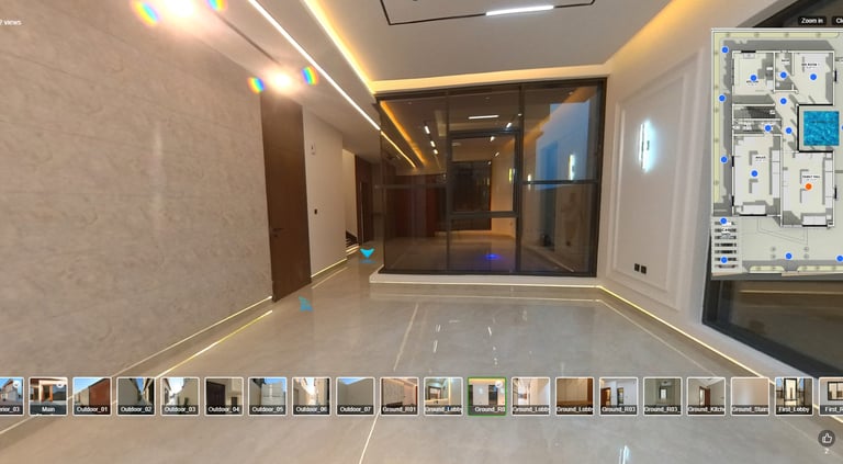
El Helow Villas
➤ Ajman, UAE 𝄜 2025
To create an online interactive walkthrough that allows prospective buyers or users to explore villas remotely without requiring a physical visit.
Workflow
360 Virtual Documentation
Interactive Real Estate Visualization
Digital Walkthrough Development
Spatial Information Integration
Digital Deliverables
Online Interactive Tour
Dynamic 360 Walkthrough
Villa Layout References
Space Information Layers
Navigation Shortcuts
The developer needed a dynamic digital presentation for completed villas that could be shared online with prospects. The experience had to allow users to navigate through the villa, understand the layouts, access information about spaces, and move quickly between key areas. X-Dimension developed an interactive 360 tour that connected visual navigation with spatial and layout information, supporting remote property presentation and digital real estate marketing.
Project Purpose
Project Context
Why It Mattered
The project enabled remote property exploration and helped the developer present villa spaces digitally, improving accessibility for prospects and reducing dependence on physical visits.
ProMark Mall
➤ Cairo, Egypt 𝄜 2022
To document the actual concrete structure of a mall and produce accurate engineering drawings to support curtain wall fabrication and installation.
Workflow
Reality Capture
Structural As-Built Documentation
Construction Deviation Verification
Engineering Drawing Production
Facade Coordination Support
Digital Deliverables
Registered Point Cloud
2D Engineering Drawings
Structural As-Built References
Curtain Wall Coordination Documentation
The curtain wall contractor faced issues because the actual concrete structure deviated from the design documents received. Accurate documentation was needed to identify the true as-built dimensions and provide reliable references for manufacturing and installation. X-Dimension performed accurate scanning and converted the captured data into engineering 2D drawings that reflected the actual site condition. These drawings became a practical reference for producing curtain wall elements aligned with the real structure.
Project Purpose
Project Context
Why It Mattered
The project helped the contractor manufacture and install curtain wall elements based on actual site conditions, reducing rework and resolving coordination issues caused by structural deviations.
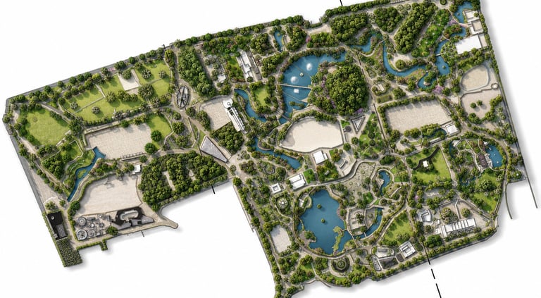
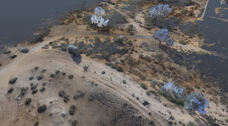
Giza Zoo
➤ Giza, Egypt 𝄜 2023
To create full 3D and 2D documentation of one of Africa and the Middle East’s oldest zoological parks before a major renovation project.
Workflow
Reality Capture
Landscape Documentation
Heritage and Site Documentation
Terrain and Level Review
Tree Information Mapping
Digital Deliverables
Registered Point Cloud
2D Drawings
Site Documentation Reports
Tree and Landscape Information
Spatial Design References
Giza Zoo contains a combination of landscape zones, heritage assets, buildings, trees, and public spaces. The renovation required accurate documentation of the existing environment and careful consideration of significant trees that could not be removed. X-Dimension documented the zoo, revised traditional grid leveling work, and helped the design team understand tree trunk positions at specific heights for integration into the design process. The project also supported the addition of tree-related information in collaboration with expert personnel.
Project Purpose
Project Context
Why It Mattered
The project created a comprehensive digital reference for a sensitive landscape and heritage environment, helping designers plan renovation works while respecting existing trees, buildings, and site features.
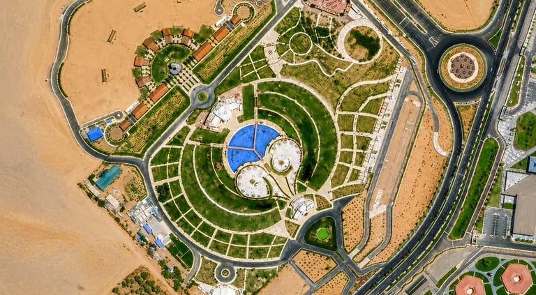
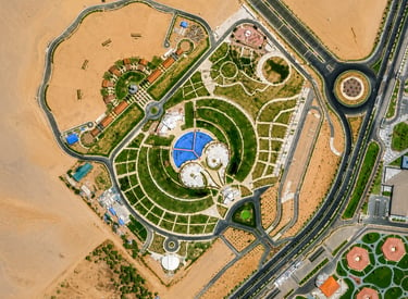
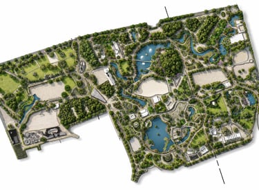
Peace Park
➤ Sharm El-Sheikh, Egypt 𝄜 2022
To create full spatial documentation of Peace Park and its surrounding area to support planning, understanding, and future development or maintenance works.
Workflow
Reality Capture
Landscape Documentation
Site and Surrounding Area Documentation
2D Drawing Production
Digital Deliverables
Registered Point Cloud
2D Drawings
Zone Documentation
Building and Surrounding Area Records
Peace Park is a major public landmark and recreational area in the heart of Sharm El Sheikh. The project required documentation of the park zones, surrounding area, buildings, and spatial relationships within the landscape environment. X-Dimension captured and documented the site to create reliable drawings and spatial records for future reference.
Project Purpose
Project Context
Why It Mattered
The project provided a reliable digital reference for a major public landscape asset, supporting future planning, maintenance, and site understanding.
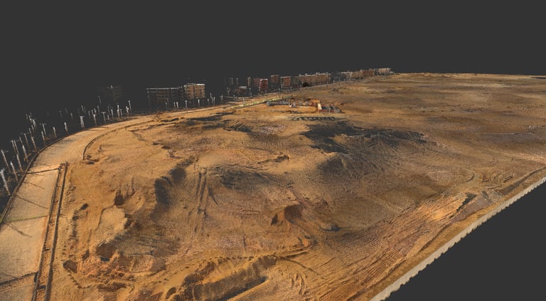
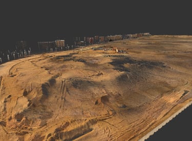
Elaia Compound Land
➤ Cairo, Egypt 𝄜 2025
To document a development land plot and support cut-and-fill optimization for a future compound project.
Workflow
Reality Capture
Topographic Documentation
Digital Terrain Modeling
Cut-and-Fill Analysis
Earthworks Planning Support
Digital Deliverables
Registered Point Cloud
Digital Elevation Model
Drawings
Cut-and-Fill Reports
Volume Calculations
The client needed an accurate representation of the land to plan a complex compound development and study how to optimize cut-and-fill operations. X-Dimension scanned the land, created a digital representation, and developed a visual study showing where cut and fill would be required. The work included volume calculations for different locations to reach the required levels, as well as recommendations on how excavated material could potentially be reused for fill and how the process could be planned efficiently.
Project Purpose
Project Context
Why It Mattered
The project helped the client understand the land condition, optimize earthworks planning, reduce uncertainty in cut-and-fill quantities, and make better use of available site material during development planning.

Al Rahmanneya Land Plot
➤ Ajman, UAE 𝄜 2024
To provide accurate land representation and cut-and-fill quantity verification for a land plot.
Workflow
Laser Scanning
Topographic Documentation
Digital Terrain Modeling
Cut-and-Fill Verification
Quantity Review Support
Digital Deliverables
Registered Point Cloud
Digital Elevation Model
Drawings
Cut-and-Fill Reports
Earthwork Quantity Calculations
The landowner required an independent and accurate calculation of cut-and-fill quantities after a contractor had already submitted quantity survey results for billing. X-Dimension used laser scanning to produce a more accurate digital representation and calculate the required earthwork quantities. The analysis showed that the required quantities were approximately 20% less than the quantities calculated by the contractor, providing the owner with a stronger basis for review and decision-making.
Project Purpose
Project Context
Why It Mattered
The project provided the owner with accurate earthwork quantities, supporting cost control, contractor review, and more confident decision-making based on measurable land data.
Ready to Start Your Project?
Join our growing list of satisfied clients and experience the X-Dimension difference.
Stay connected
Follow us on social media for the latest updates and project showcases.
© 2026 X-Dimension. All rights reserved.
Quick links
Ready to start your project ?
Discuss the project and solution with our team